

Boletín de aludes

Provo

Utah Avalanche Center
Ver en el mapa

Peligro de aludes

  • Alta montaña
  • Límite del bosque
  • Bajo el límite del bosque
Desactualizado: este boletín caducó 6 months ago. Estás viendo condiciones pasadas, no el boletín vigente.

Lo esencial

The avalanche danger is LOW and Normal Caution is advised.

Wet loose sluffs may occur with daytime warming. The buried PWL (persistent weak layer) is mostly dormant and triggering one of these hard slabs is unlikely but not impossible.

Remember that risk is inherent in mountain travel.

Problemas de aludes

  • Persistent Slabs

    • Alta montaña
    • Límite del bosque
    • Bajo el límite del bosque
    Probabilidad
    Unlikely
    Tamaño
    2

    The Dry January Layer (DJL) of faceted snow is 1-3 feet deep and buried by a strong slab and supportable crusts, with the last reported avalanches failing on the DJL on Feb 21st near the Ant Knolls on the Wasatch back.
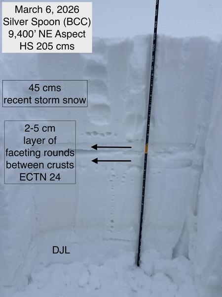
    We now view the PWL as dormant and human triggered avalanches are unlikely but not impossible. If you're looking for trouble, however, you may find it in recently wind loaded, steep, thin, rocky terrain in the highest elevations on the north side of the compass.

    Looking ahead: with the skyrocketing temperatures next week, we anticipate the PWL becoming active again as melt water percolates down to the faceted grains and wet slab avalanches become our central avalanche problem. Stay tuned.

General Announcements

This information does not apply to developed ski areas or highways where avalanche control is normally done. This forecast is from the U.S.D.A. Forest Service, which is solely responsible for its content. This forecast describes general avalanche conditions and local variations always occur.

Observations and Avalanches

Backcountry Emergency Procedures

SMS Notifications

Instagram

Facebook

Get Forecast Email

Previous Forecasts

Contact via email

Submit Observation

Recent Activity

Wet loose avalanches were noted in steep solar terrain prior to Tuesday night's cold front.

Snow and Weather

Skies are clear. As of 5AM, temps are in the upper 20s to mid 30s. Winds are blowing from the west, blowing 20-30mph with gusts to 40. A ridge of high pressure parked off the California coast shields us from the storms, pushing them into Idaho, Wyoming, and Montana. But at least we'll see wind.

For today, we'll have mostly sunny skies with some high cirrus floating through. Winds will remain moderate to strong from the northwest; temps will rise to the upper-30s up high, the upper 40s down low. Riding conditions: sun, temperature, and wind crusts dominate the landscape. With proper timing, you'll find soft and creamy corn skiing on solar aspects. With improper timing, you'll find scary and teeth-rattling slide-for-life conditions on the frozen crusts on the early side and unsupportable glop and wet sluff potential on the late side.

The Outlook: A STRONG cold front crashes through on Saturday, plunging temperatures to the low single digits, but alas it's a mostly dry cold front. We may see 1-3" if we're lucky. Spring rebounds next week and (read this slowly...) indeed it does look as if the sun - yes, our sun - touches down mid-week (GFS weather model below) as mountain temperatures soar into the 50s up high with little to no refreeze. Side note - there is a better than even chance that valley temps exceed 80°F on Wednesday. According to the NWS, this would smash the record for the earliest 80°F day in Salt Lake City, with the previous record earliest 80°F day occurring on March 31st.

Regiones cubiertas