
Quick report
• We traveled into Central Glacier Park today to document snowpack structure ahead of the spring snow removal operations on the Going-to-the-Sun Road in the coming weeks. • Primary questions today regarded northerly aspects, as three of the initial paths encountered by work crews above Avalanche CG have north facing start zones. We were curious about the March 20th (Equinox) Crust and the persistent weak layer's responsible for very large hard slab avalanches in the region during the past few months. • To what elevation can the March 20th crust be found on northerlies? How deep did meltwater percolate during the warming event responsible for the March 20th crust? Is the February 3rd Crust/Facet combo still intact, and will it propagate in an extended column test? • Answers in the snowpack tab. No signs of instability observed during today's patrol.
Weather
- Cloud Cover
- broken
- Wind Loading
- light
- Rain Elevation
- 4500
- Recent Snowfall
- 5
- Snow Avail For Transport
- small smounts
Mostly Cloudy skies, with brief periods of sunshine peeking through early morning and late afternoon. At upper elevations, we observed 2 inches+ of soft surface snow on windward slopes, and 10+ inches on sheltered northerlies. Winds remained calm most of the morning to our highpoint of 6700'. Around 3:30pm, we were back at middle elevations in Snyder Creek but observed some blowing snow high on Mount Brown above 6000'.
Snowpack
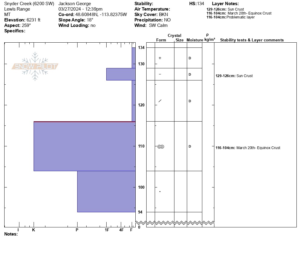
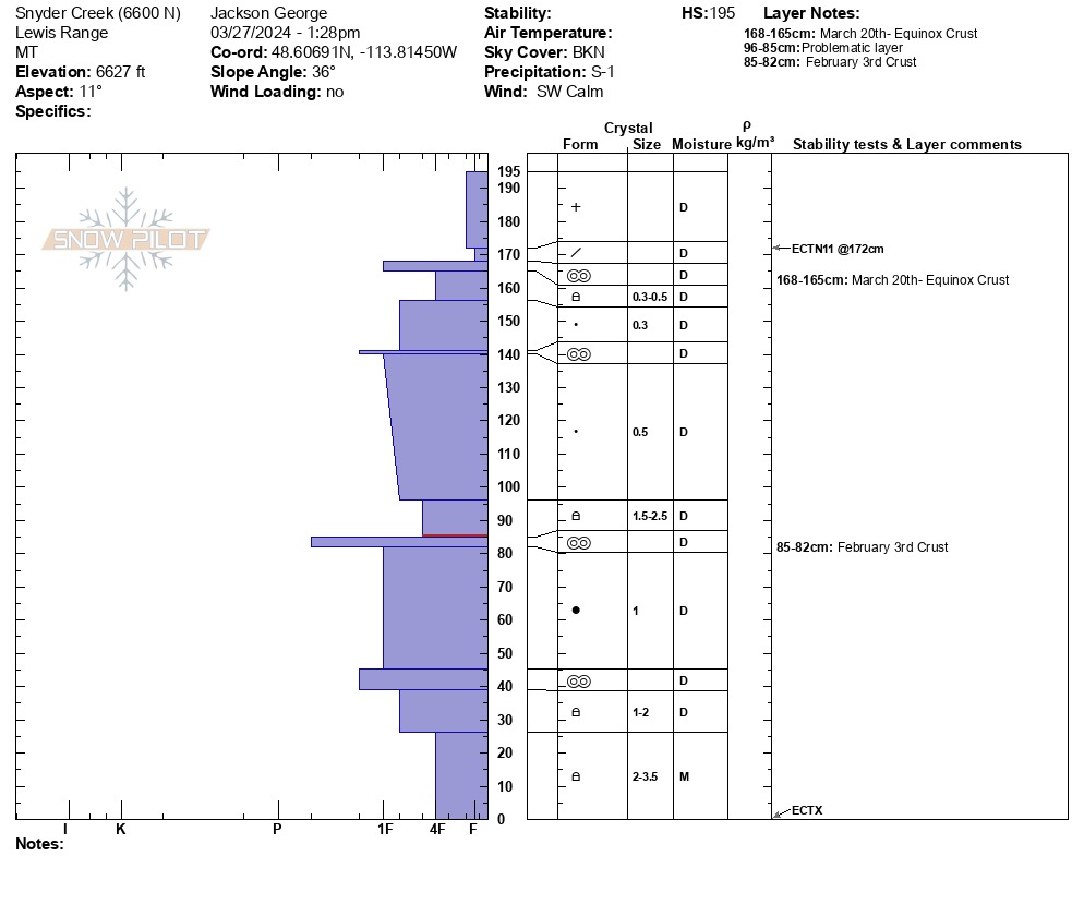
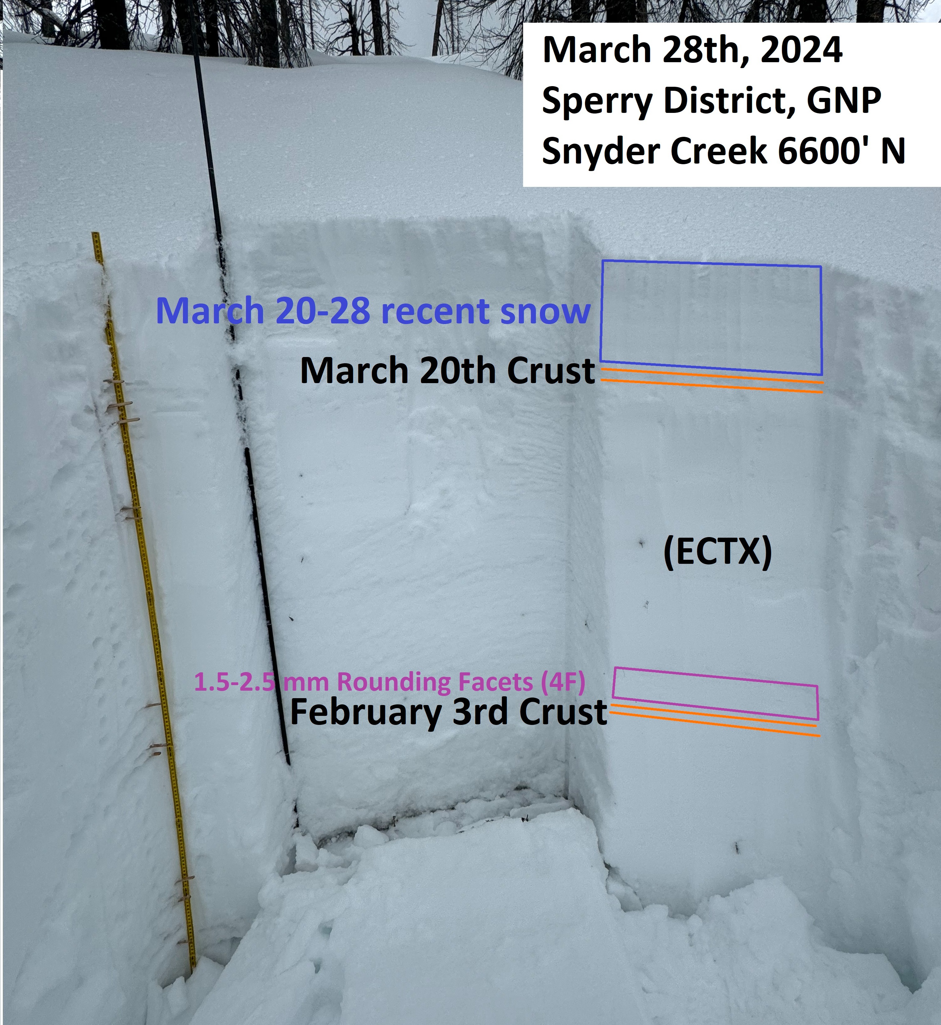
• Dug a very quick hand pit on a west/southwest slope at 6200'. March 20th crust is stout (12cm thick and knife hard) with about 18 cm of recent snow top. Unfortunately, there is a thin breakable sun crust within the 18cm of recent snow. HS=134cm at this location. (See pit profile attached) • Dug a deeper pit at an upper elevation north facing site. Had plans to only dig as deep as the Feb 3rd faceted crust, but this layer was not particularly obvious at this location, so we ended up digging all the way to the ground to be more sure of what we were looking at. • We were surprised by a few things at this pit site. First was that the Feb 3rd faceted crust was not as distinct as we have seen at other locations this winter. The 2/3 was about 110cm beneath the surface and presented as a thin (3cm) decomposing crust. Resting above the crust, we found soft (4F+) medium sized (1.5mm-2.5mm) rounding facets. This layer did not produce results in our Extended Column Test (ECTX). • The Equinox crust was present on this upper elevation northerly slope, but also relatively thin (3cm thick). Our pit site was at 6600', and I would speculate that this crust begins to dissipate above about 7000'. That is where I would be most concerned about continued reactivity of weak layers buried deeper in the snowpack. • The second thing that we noticed in our pit that left us with more questions than answers, was that the bottom 26cm of the snowpack was moist. This was curious to me, as we felt that the thin Equinox Crust was an indicator that warming was minimal on this north facing slope. Meaning that melt water percolation would have been equally minimal on this slope during the period of warm sunny days. However, the presence of moist snow at the base of the snowpack might suggest otherwise? (See pit profile attached) • No signs of recent wind loading or wind slabs in the area we traveled today. • We felt comfortable skiing one at a time through steeper NE-N-NW facing terrain today. No signs of instability on descent. Recent snow remained dry on north facing until about 5400'.