
Quick report
- Collapsing
- isolated
Quick trip up to Two Ocean to track any changes and investigate recent snow and wind. In general, the status quo remains. It's not out of the question that you could trigger a large avalanche 2-3 feet deep that fails at the January drought facet layer. The snowpack continues to strengthen, and the likelihood of a large avalanche remains low. I suspect it would have to be a very steep, shady, potentially rocky or wind-affected area (thin) to impact weak layers. The question going forward will pertain to very warm termperatures schedules to arrive on Wednesday and stick around into the weekend. There is a lot of cold, dry loose snow on Togwotee that will shed. But how warm will it get, and will deeper layers be affected by heat and potentially water running through the snowpack? Stay tuned.
We dug two pits...
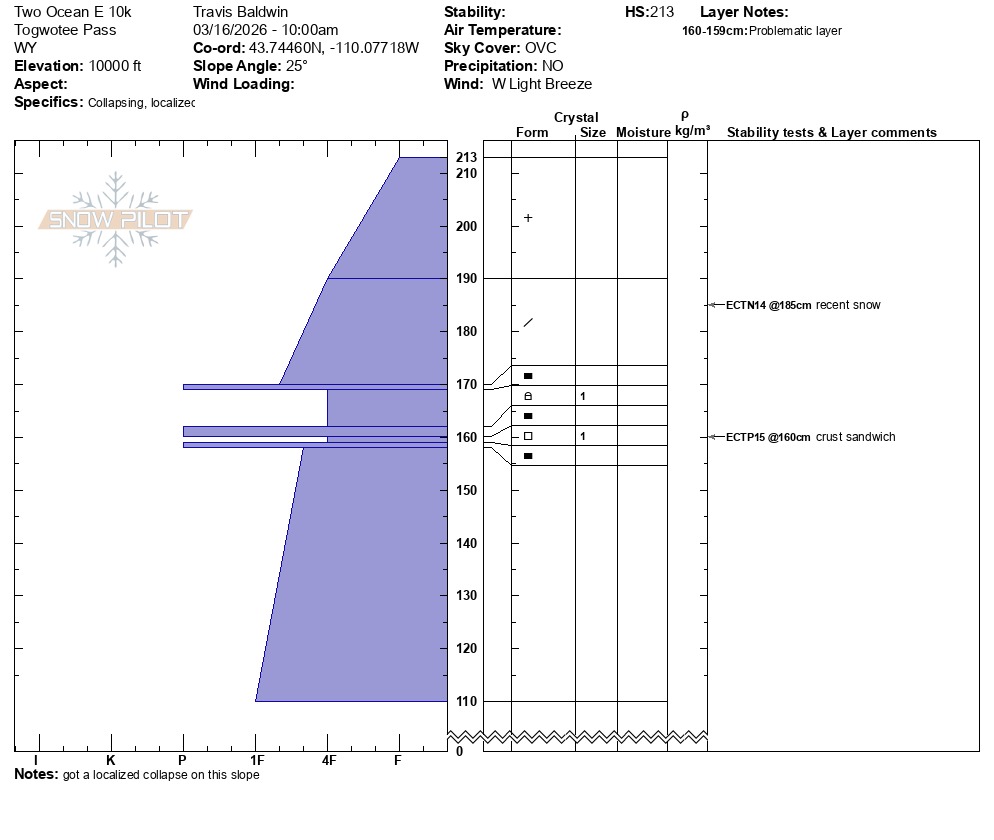
1: 10,000 feet, East Aspect HS 84 inches (213 cm). ECTP15 down about 22 inches. This failure occurred in facets between a crust sandwich just above the January drought facet layer. Notably, we did have a localized collapse here after leaving the pit and skinning uphill. This was the only significant sign of instability today (with the exception of small, soft, and shallow wind slabs along the ridge above 10k feet).
2: 9,700 feet NNE: ECTX. There was one very thin crust about 20 inches down, but nothing like the first pit. No propagation. Drought layer facets were down about 33 inches (85 cm).
We got one collapse on the east face of two ocean at 10,000 feet. This is in the same spot where we got propagation in our pit (see pit details). No other signs of instability.Weather
- Cloud Cover
- overcast
Felt like winter on Togwotee today. 18F at the car and light to moderate NW breeze moving recent snow around a little. Several new inches of snow from this morning on top of several more inches from the last few days.
Snowpack
Recent snow from the last several days ranges from a few inches to about 8-10 inches. This recent snow is covering a variety of surfaces, including crusts on southerlies and windboard at upper elevations from recent strong winds. Recent snow has been blown around some, but remains soft in sheltered areas above 10,000 feet. Soft, shallow (4-6") wind slabs have formed along ridgelines. While we didn't see any evidence of harder wind slabs formed during last week's wind event, larger, stubborn slabs may exist beneath recent snow.