
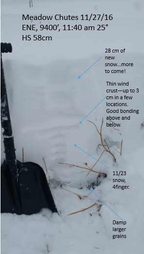
Quick report
- Aspect
- Northeast
- Red Flags
- Heavy Snowfall, Wind Loading
- Elevation
- 2865 m
- Slope Angle
- 25°
- Red Flags Comment
- <p>High PI/rapid loading. Snow density was light, but added perhaps 8 inches over the course of our tour on top of another 9 that had fallen the night before? Wind loading was not an issue yet in our touring location, but I suspect it will be a player tomorrow.</p>
Winter!! Hard to believe its actually happening!
For stunning snowflake images, check out observer Doug Wewer's site at desertsnowphotography.com. But anyone can appreciate what these flakes mean for skiing.
Snowpack
- Instability Comment
- <p>Hard to add almost 20 inches of light snow without sluffing. In our area, nothing longrunning. Steeper shots or continued precip could change that equation.</p> <p>We didn’t reach elevations with basal facets to worry about, but I’ll be curious to see if the new snow loading activates anything on the higher NE aspects</p>
Lots of light new snow on top of whatever existed before this storm. Low SE had a melt crust below that would crack around skis, low NE did not. Higher (9500’) had older wind crusts of varying thickness, which (by burping and pull testing) seemed well bonded above and below. There was also evidence of the older (pre 11/23) snowpack up in NE locations, but the grains were damp. ECT tests rather inconclusive: soft upper pack overlying shrubs made for difficult interpretation. Overall, danger in our touring area seemed low except for all the new snow that kept coming down!