
Quick report
- Aspect
- North
- Red Flags
- Cracking, Poor Snowpack Structure
- Elevation
- 2438 m
- Slope Angle
- 25°
- Red Flags Comment
- <p>Cracking confined to just under skis. </p> <p>Still dealing with the typical Uinta persistant weak layers. </p>
I wanted to get out and ride some low elevation terrain today in anticipation of a warmup in the next few days. Low elevation terrain is nicely filled in and still holding soft snow so I wanted to take advantage before it got crusty. Plus, I love skiing in the mountain mahogany. The rain crust can be felt below about 7400 feet but wasn't a problem when skiing.
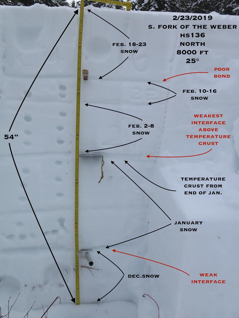
The snow depth at just under 8K was about 4.5 feet deep on a north facing slope. The weakest interfaces were above the temperature crust that formed at the end of January and close to the ground at the December/January snow interface. I don't think there was much or any Oct. or early Nov. snow in this location. Extended column tests did not propagate across the column but failed in the same places as my column tests. Column tests produced clean shears with easy to moderate effort to fail 29 cms down (11") and 64 cms down (25"). With harder effort, I also had failure at the December/January snow interface. I think the cold temps and time without a big load have trended the snowpack to being more stable. I'm curious if the pack will be more prone to coming unglued with warmer temperatures on the horizon, especially on south and east facing slopes (I've been finding crappy structure on south facing slopes with a lot of spacial variability). Lately I've been finding the weak snow above the crust that formed at the end of January as the weakest persistent layer but there are multiple persistent weaknesses in the snowpack.
The danger where I was was low to moderate. Moderate because I did push the slope angle a bit. I think the danger will trend about the same over the next couple of days but may increase by mid week with warmer temps forecasted, especially at low to mid elevations where the snowpack may not get a good refreeze at night.
Snowpack
Low elevation still holding soft snow. Wide spread weakening of the snow surface taking place.