

Lawinenlagebericht

Salt Lake

Utah Avalanche Center
Auf der Karte ansehen

Lawinengefahr

  • Hochgebirge
  • Waldgrenze
  • Unterhalb der Waldgrenze
Veraltet — dieser Lagebericht ist 2 years ago abgelaufen. Du siehst vergangene Verhältnisse, nicht den aktuellen Bericht.

Kernpunkte

The avalanche danger will rise to HIGH today on upper-elevation slopes, with a CONSIDERABLE danger on mid-elevation slopes and MODERATE danger at low elevations. Expect natural avalanches to occur, with human-triggered avalanches very likely.

Heavy snowfall and strong winds will create dangerous avalanche conditions, especially on northerly-facing slopes at the mid and upper elevations where avalanches may break several feet deep and hundreds of feet wide. Watch for rapidly changing conditions today, especially during any period of heavy snowfall and/or wind drifting.

Lawinenprobleme

  • Wind Slabs

    • Hochgebirge
    • Waldgrenze
    • Unterhalb der Waldgrenze
    Wahrscheinlichkeit
    Likely
    Größe
    2

    Strong winds have created sensitive wind drifts on all aspects at the mid and upper elevations. Watch for cracking as an indication of sensitive conditions. Cornices have also grown large and sensitive and may break much further than expected.

    On northerly-facing slopes, any avalanche involving wind-drifted snow may step down to a deeply-buried persistent weak layer.


  • Storm Slabs

    • Hochgebirge
    • Waldgrenze
    • Unterhalb der Waldgrenze
    Wahrscheinlichkeit
    Likely
    Größe
    2

    The storm snow may be reactive today, failing within density inversions or at the interface with the old snow surface.

    On northerly-facing slopes, any avalanche involving storm snow may step down to a deeply-buried persistent weak layer.
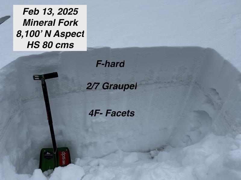
  • Persistent Slabs

    • Hochgebirge
    • Waldgrenze
    • Unterhalb der Waldgrenze
    Wahrscheinlichkeit
    Possible
    Größe
    3

    Two buried weak layers of faceted snow in the snowpack continue to be triggered by skiers and riders, with the most recent avalanche occurring on Thursday in Butler Basin.

    • The upper weak layer is buried around 1–2.5 feet deep, formed during the cold weather at the end of January.

    • The lower weak layer, near the ground, formed in November/December and has caused many large avalanches this season. This layer is most likely to be triggered in steep, thin snowpack areas, and repeater slopes—places that have previously avalanched - such as Thursday's avalanche in Butler Basin. Avalanches up to 1–3+ feet deep are possible.

    These two weak layers are primarily found on north-facing slopes, with some east and west-facing pockets at mid and upper elevations, with widespread spatial variability. Heavy snowfall and strong winds will overload these weak layers, with large, destructive avalanches possible.

Avalanche Warning

What

The avalanche danger for the warning area is HIGH today and may rise to EXTREME in some areas this weekend.

When

Very dangerous avalanche conditions are expected through the weekend.

Where

For all the mountains of Utah and Southeast Idaho, including the Wasatch Range, Bear River Range, Uinta Mountains, Wasatch Plateau, Manti Skyline, the La Sal Mountains, the Tushar Range....

Impacts

Heavy snow and drifting by strong winds have created widespread areas of unstable snow and very dangerous avalanche conditions at all elevations. Natural and human-triggered avalanches are likely. People should avoid travel in all avalanche terrain and keep out of avalanche runouts. This means you should stay off of and out from under slopes steeper than 30 degrees.

Special Announcement

  • A preliminary report on Saturday’s avalanche fatality in the East Bowl of Silver Fork can be found [HERE]. We hope to have the full report out very soon.
  • The full report on the February 3rd avalanche fatality on Monte Cristo (Ogden Mountains) is published [HERE].
  • The accident report detailing the full and partial burial close call in Dutch Draw (Park City ridgeline) from Saturday is available [HERE].

Recent Activity

There was a close call in an avalanche in Butler Basin on Thursday involving two partial burials [photo below]. The avalanche was 2.5 feet deep and 150 feet wide, breaking down into old faceted snow. This was yet another repeater slope that had avalanched on January 12.

Many observers found shallow sensitive wind slabs on all aspects at the mid and upper elevations on Thursday.

Observations and Avalanches

Snow and Weather

This Morning: Temperatures are in the low 20's F and winds are from the south/southwest, gusting 30-50 mph along exposed ridges up to 10,500' and over 60 mph at 11,000'.

24-hour snow/water totals as of 5 am:

Little Cottonwood: 6-10"/1.4"

Big Cottonwood: 5-10"/1.5"

Park City Ridgeline: 7-14" (1"+ water)

Today: The National Weather Service has issued a winter storm warning most of the mountains in the state. Today's snowfall arrives on a southwest flow that isn't that favorable for the Cottonwoods, although snowfall totals of 5-10 inches are expected by sunset. Temperatures will rise into the upper 20's F and south/southwest winds will remain moderate to strong at the mid and upper elevations. Today's rain/snow line will hover around 6,000'

The flow switches to the northwest this evening, a setup that should be more favorable for the Cottonwoods with heavy snow expected. Snow will continue through Saturday, followed by a brief break Sunday morning, with another storm entering the region Sunday afternoon and into Monday. The pattern appears to remain active.

Nikki's Week in Review is available. Please use this valuable resource as a regular part of your backcountry planning.

General Announcements

CLICK HERE FOR MORE GENERAL INFO AND FAQ

This information does not apply to developed ski areas or highways where avalanche control is normally done. This forecast is from the U.S.D.A. Forest Service, which is solely responsible for its content. This forecast describes general avalanche conditions and local variations always occur.

Observations and Avalanches

Backcountry Emergency Procedures

SMS Notifications

Instagram

Facebook

Get Forecast Email

Previous Forecasts

Contact via email

Submit Observation

Abgedeckte Regionen